Utah has my whole heart. Okay, maybe I’ve said that before, but seriously this state is so beautiful and cannot be solely depicted in a photograph, or multiple for that matter. You have to come and visit. We’ve actually been to Utah twice on our trip thus far. The first time we were supposed to be in Yellowstone National Park, but got diverted due to a massive snowstorm. Instead we made the trek from Wyoming straight to Heber Valley (Near Salt Lake City) and spent five days exploring Utah’s North Country. The second time was prior to Thanksgiving, when we left Joshua Tree National Park and drove through Arizona, Utah and Colorado all in one day. In both instances, we didn’t fully get to embrace all the state has to offer, so we planned to come back to do the “Mighty Five,” during the second half of our journey.
In Utah there are five National Parks, known as the “Mighty Five.” These include: Arches, Canyonlands, Bryce Canyon, Capitol Reef and Zion. Based on the size of the state, Utah has a significant number of National Parks, but surprisingly ranks third in number of parks, behind California with nine and Alaska, with eight. Colorado and Nevada both have four. So, if you’re looking to visit multiple National Parks, spending time in Colorado, Utah and Nevada makes sense because they border one another, which will save you time driving and allow you more time for fun.
I hope when you finish reading this post you’ll leave with at least one takeaway, whether it’s a travel tip, fun fact or new destination to add to your own personal bucket list. Sometimes I think my posts act more as a personal journal entry, but because we are so passionate about Utah and the parks, we want to make sure we’re sharing our knowledge so our friends can also visit and hopefully have an unforgettable experience.
When planning a trip to Utah you should first decide whether you want to begin in the North or the South. The majority of people we’ve met fly into Las Vegas and drive two hours to Zion before heading Northeast to the other four parks. The other option is to fly into Denver, drive to Moab, then begin from there. We began in Moab, so I will walk you through how we went about it. Moab is located about half-way up on the Eastern part of the state and is easily accessible from Colorado. From the East Coast, it makes sense to fly into Colorado. Denver would likely have the most reasonably priced flights, but the drive from Denver to Moab is five hours, so it’s not a quick thing. Another option would be to fly into Grand Junction, Colorado then drive to Moab (An hour and a half drive). Grand Junction is known for their mountain biking and has many trails to do so. Mike actually bought his bike in Grand Junction. They have more bike shops than anywhere. Also, nearby Fruita, Colorado is where we camped for several days and ended up storing our camper while we were away for Thanksgiving. Fruita is a quaint little town, with many trails and it’s home to a state park, Dinosaur Museum and the State’s National Monument.\
Moab, Utah is home to Arches National Park, Dead Horse Point State Park and Canyonlands National Park. Don’t let the fact that Dead Horse is labeled as a State Park fool you. It is just as breathtaking as the National Parks surrounding it and is a must-see when visiting Moab. It’s been compared to the Grand Canyon due to its monumental size and deep cliffs surrounding the Colorado River that flows through it. The City of Moab has certainly become a top destination for both in and out of state travelers. Apart from the fact that it’s home to two of Utah’s five National Park’s, the city is surrounded by dramatic scenery and endless opportunities for adventure-seeking visitors. We would suggest staying at the Moab Valley RV Park and Campground, located only five minutes from the park and a few miles from the town. If you are planning to stay in a hotel, book early (Especially for the Summer months), and know that there are several options available.
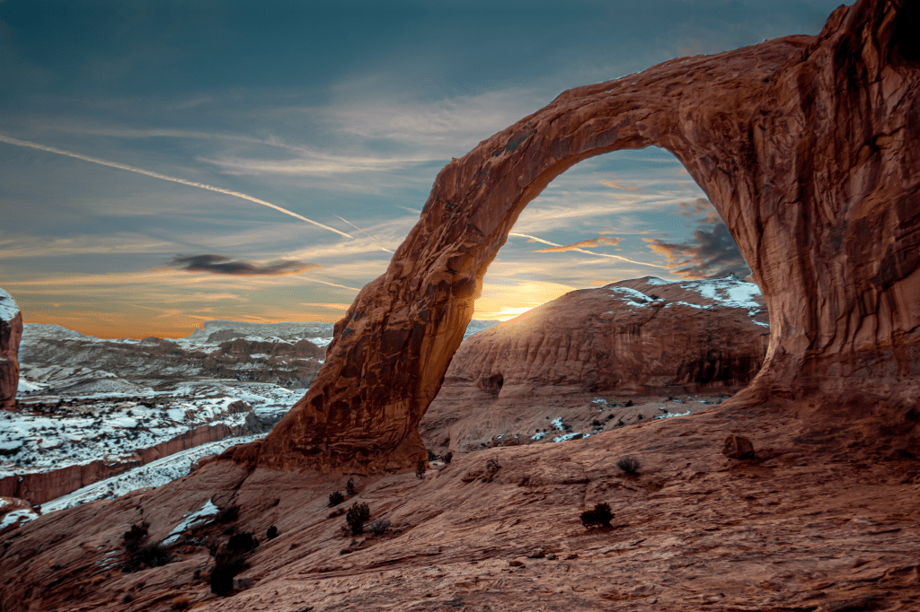
Arches National Park (Moab, Utah)
Arches, NP was breathtaking, despite the fact that we were there on one of the busiest days of the off-season. It was New Year’s Day, so parents were off of work and children were everywhere. With that being said, all National Parks enforce COVID restrictions and require masks, so we did feel safe, despite the crowds. We haven’t run into full parking areas and crowds at all because we’re traveling during the so-called “Off-season.” That is certainly a perk of traveling in late Fall/Winter. So if you do visit Arches in the off-season, plan to do so on a weekday, if you have the opportunity.
From our campsite in Moab Valley RV Campground, it took only a few minutes to reach the park… After driving up several switchbacks your jaw will drop at the sight of the salmon-colored geological formations. According to the National Park Service, Arches National Park has the highest density of stone arches in the world, with just over 2,000 documented arches. And that does not include the pinnacles and other rock formations in the park. Another super appealing feature of Arches is it’s accessibility. For less mobile folks, or parents with young children, the park is welcoming to all. Many of the trails leading to the arches are short and flat and are ranked “easy” by the National Park hiking guide.
Must-Do’s in Arches, NP
- See Balanced Rock off of the main road, you can either see it from your vehicle or do a short hike around it (It stands at 128 feet tall and weighs 3,600 tons)
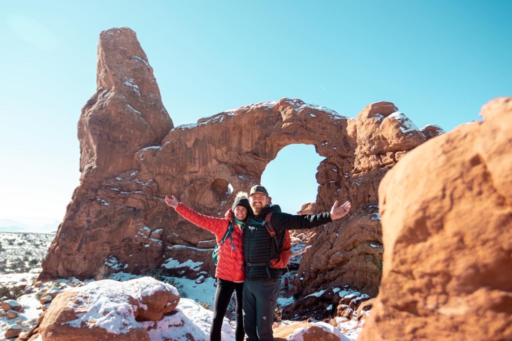
- Hike the Windows Trail Loop (1.2 miles total) You can see the North Window, South Window and Turret arch all in one short hike
- Delicate Arch is one of the most famous geologic structures in the world. You may recognize it from the Utah license plate. The hike is considered moderate to strenuous and is 3 miles out and back. Unfortunately the hike was closed due to snow and ice when we visited, so we admired it’s beauty from the Delicate arch upper viewpoint, another short hike that is accessible to most.
- Hike the Devils Garden Trail (1.9 miles out and back) and you’ll have the opportunity to see multiple arches along the way including: Pinetree Arch, Tunnel Arch and Landscape Arch (The longest natural arch in North America)
- A few other arches we admired include: Broken Arch, Skyline Arch, Sand Dune Arch, and Double Arch
We would recommend spending one to two full days in the park, before moving on to some of Moab’s other natural treasures. We hiked 9 miles total in one day, so it may be best to spread your hikes out across a couple days if you prefer a less strenuous “vacation.”
Corona and Bowtie Arch Trail (Moab, Utah)
We met a nice gentleman, who also happened to be our neighbor in the campground. He suggested we spend a few hours checking out Corona Arch, which was located about 15 minutes West of our Campground and Arches NP. His suggestion appealed to us initially because the hike allowed dogs and didn’t have an entry fee. We arrived at the parking area around 4pm and asked a couple girls in the parking lot if they thought we could make it to the arch in time for sunset. They confirmed we shouldn’t have an issue, so we began our hike, walking more briskly than normal.
Berk climbed the rocks, quicker than Mike and I could make our way up them, so he inevitably led the way. We hiked through the snow that had not yet melted, along narrow paths covered in thick red dirt and up mounds of rock, following the Cairns along the way. Cairns are rocks stacked by Park Rangers to show hikers the right way. There are also green paint marks that mark the center of the trail, so it’s important to follow these markings. About a mile and a half into the hike, we reached a ladder, and without thinking I quickly climbed up it. Berkley tried to follow, scaling the steep slickrock alongside the ladder. ¾ of the way up he slid and started tumbling backwards. Thankfully Mike was below the ladder and caught him before he had the chance to hit the rock below us. It was terrifying and we were so glad it didn’t end differently. The next portion had steel cables to hold onto as we climbed up the steep grade. Michael had to carry Berk up and down this section, and did so with grace. Despite the challenge of this hike with a dog, we absolutely loved it. Watching the sunset through the magnificent beauty of the arch was breathtaking, let alone the massive rock walls surrounding every other part of the cliff we stood upon.
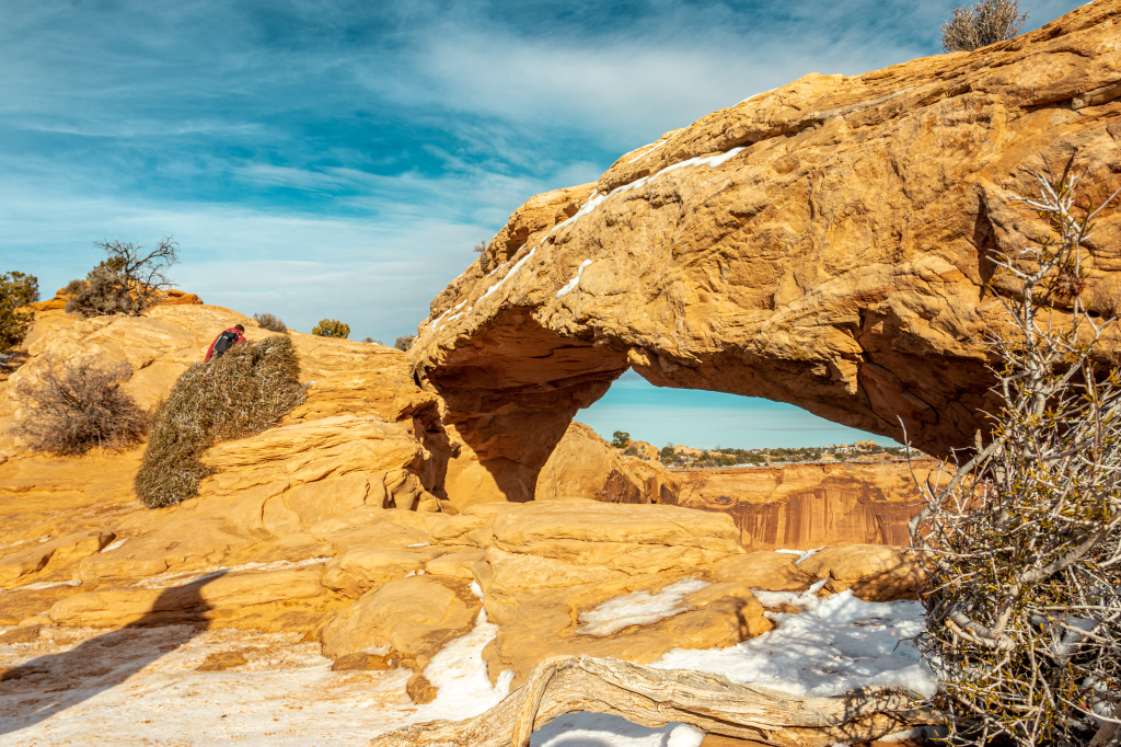
Since we were limited on time, we were only able to see the Corona Arch and the Bowtie arch, which are along the same route. If you have more time and darkness isn’t near, you can hike an additional half-mile on a nearby route to see the beauty that is Pinto Arch.
Dead Horse Point State Park (Moab, Utah)
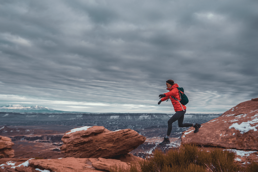
After hearing about the hype of Dead Horse Point State Park, we knew we needed to spend a day seeing what it was all about. The park is located about 30 minutes outside of Moab and is conveniently only six miles from Canyonlands State Park, so even if your time is limited it’s certainly possible to visit both in one day. Our National Parks pass does not include entry into any state parks, so it did cost us $20 for the day (Which was totally worth it). Michael also paid an extra $10 for a one-day drone permit. For the first half of our trip he had forgotten his drone at home, so he was super eager to fly it. The park typically doesn’t allow drones, but because it’s the “Off-season” and there are less people around in the Winter months, they allow them. Another huge perk of visiting Dead Horse Point is that they allow dogs, while almost all of the National Parks do not. Berk was thrilled to spend the entire day hiking with us. We liked it so much, we came back a day later to ride the Intrepid, raven run and Great Pyramid mountain biking trails, which offered completely different views from the hiking trails, so we’d suggest doing both if you have the time.

Canyonlands National Park (Moab, Utah)
Canyonlands National Park covers a massive 337,598 acres of land. The park is made up of an array of canyons, mesas, buttes, arches and spires. The park has 4 distinct sections, which include: Island in the Sky (Northern and Central) The Needles (Southern) and The Maze (Western). Island in the Sky is the most accessible and is where we spent the majority of our time.
Must-Do’s in Canyonlands, NP (Island in the Sky)
- Grandview Point, a 4-mile round-trip out and back hike with INCREDIBLE views (We went live on Instagram to share them with the world) It’s not marked well, so make sure you’re following the Cairns out to the end.
- Mesa Arch, this is the one and only arch in Canyonlands and is best photographed at sunrise. It’s tempting to stand on the arch, but it’s not allowed. A nice spot to have lunch.
- Green River Overlook- Try to arrive at least a half hour before sunset to capture the beauty of all the changing colors over the Green River. I took a time-lapse which came out really cool. This view doesn’t require much hiking at all, there’s a parking area and a two minute walk to the overlook.
Capitol Reef National Park (Torrey, Utah)
The drive from Canyonlands was about two hours to Capitol Reef National Park. The bone chilling wind kept us from getting up and out of the camper first thing in the morning. When I stepped outside, I realized we were the only ones staying at the Sand Creek RV Resort. When we arrived, the owner greeted us, and said we could choose our site because we were the only ones there. When I asked where the bathrooms and showers were, he informed us they had been closed since October 31st. Good. We thought, who needs a shower anyways? Mike went through the hassle of securing the insulation skirt around the camper (Hopefully for the last time) to ensure our pipes will stay warm enough to use our water. I packed our lunches and we headed to Capitol Reef National Park for the remainder of the day.
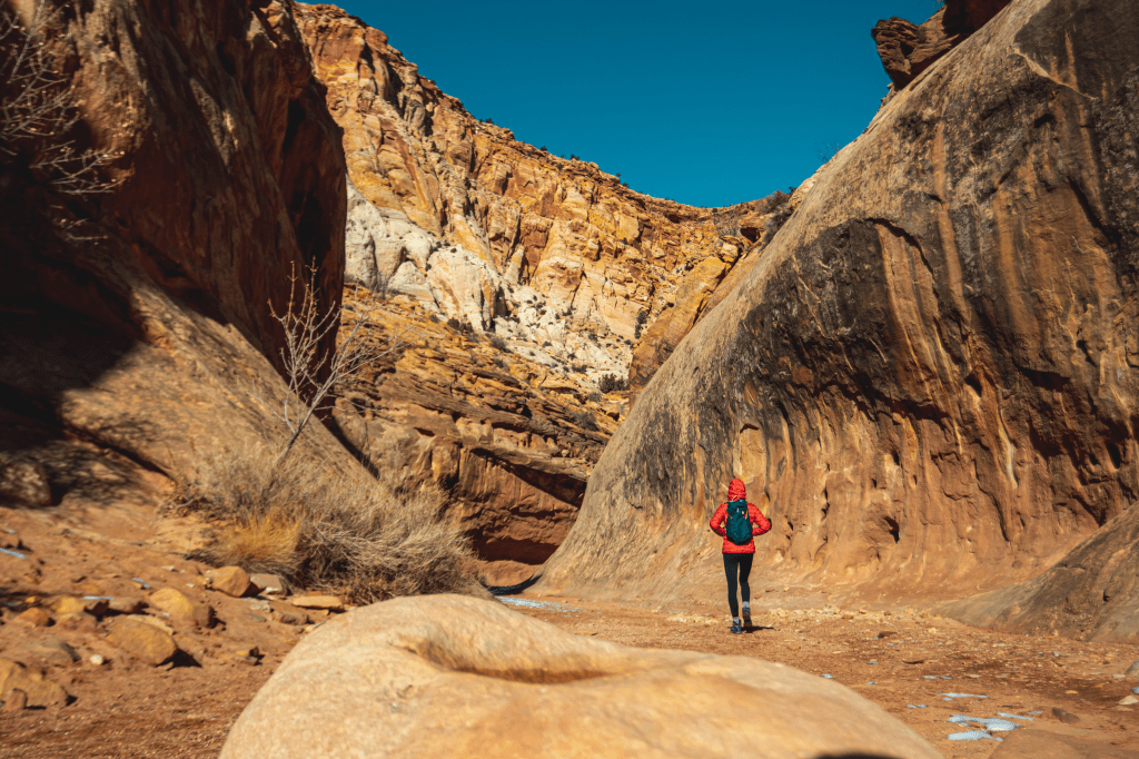
Over the span of the next four hours, we would hike a total of 8.31 miles through narrow slot canyons, over natural arches and up slickrock that lead us to the famous “Water pocket folds.” A water pocket fold is created typically in sandstone. As the rainwater dissolves the cement between sand grains, water pockets form in the earth. Capitol Reef is stunning and so different from both Arches and Canyonlands. We’ve been amazed at how different and similar their landscapes are. Even on our drives from one park to the next, Utah’s landscape drastically changes from towering salmon colored buttes and spires to green grasslands surrounded by mountainous snow covered terrain.
Must-Do’s in Capitol Reef, National Park
- Capitol Gorge is a 2 mile round-trip hike that offers deep canyon views, the opportunity to see petroglyphs (Historic native Inscriptions carved into the rock dated up to 1500 years old) as well as a short climb to “The Tanks,” which are water pockets in the rock.
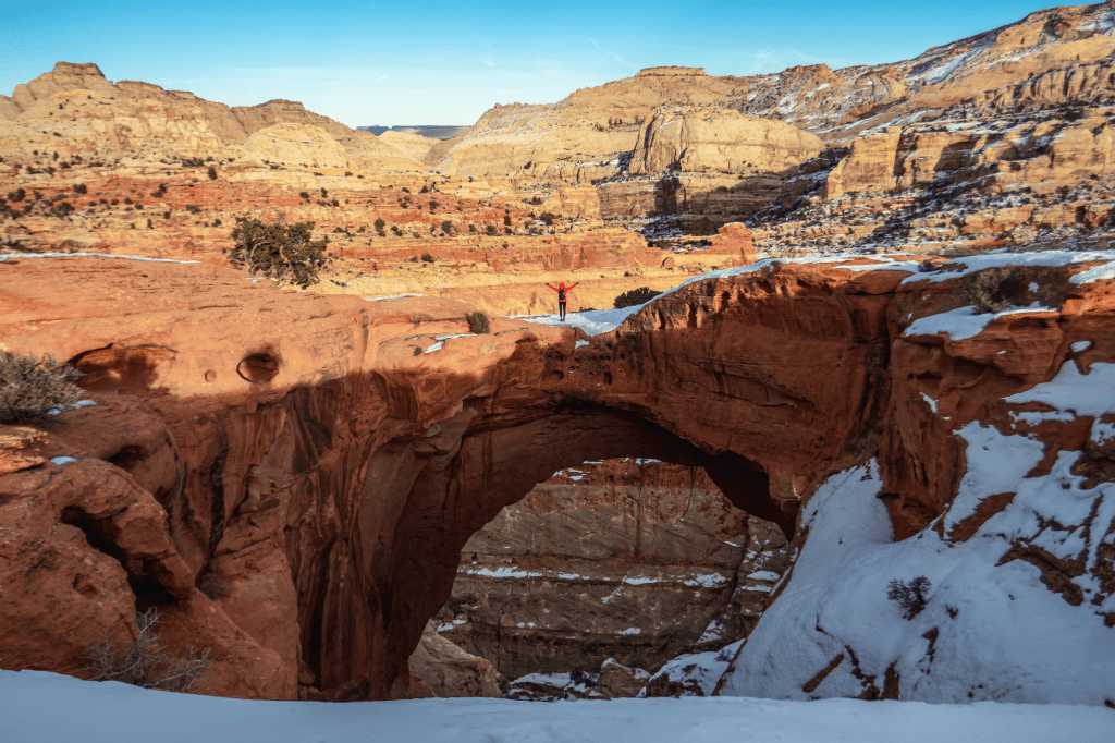
- Cassidy Arch and Grand Wash- When choosing the Grand Wash Trail, you’ll first have the chance to hike up to the Cassidy Arch, which is just shy of being a 4-mile round trip hike that is totally worth the heavy breathing the whole way up to the top. Over the course of 1.7 miles you’ll climb 670 feet in elevation and will be stunned by the 360 degree views surrounding you the whole way up. The Cassidy Arch is a natural arch surrounded by slickrock. It gracefully hangs over a canyon that my husband almost dropped his hat down when he got WAY too close to the edge.
- Goosenecks Point- A short hike to a great lookout for a sunset view of the park. We were late leaving Grand Wash and were trying to catch the end of the sunset, when I rolled my ankle sprinting over the rocks trying to catch a glimpse of color. It was embarrassing to say the least.
- If you’re visiting during fruiting seasons, you’re in for a treat. The Fruita Historic District will leave you exploring orchards full of fruit you’ve probably never heard of. Free for the taking if you pick and eat of the tree.
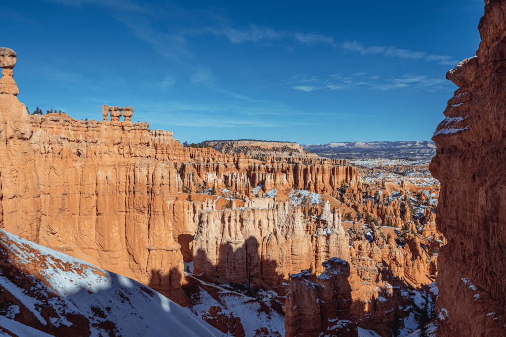
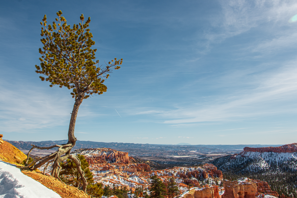
Bryce Canyon (Tropic, Utah)
We left Torrey, Utah eager to see Bryce Canyon and excited to put the cold winds behind us. We drove two hours Southeast from Capitol Reef to Bryce Canyon. When we arrived we hiked the Navajo Loop Trail, which was stunning and one we’d 100% recommend. Definitely recommend beginning at “Sunrise Point” and ending at “Sunset Point.” The hike was downright spectacular. The buttes, spire’s and hoodoo’s surrounded the narrow, snow covered path and made me feel like I was in a Disney attraction. It just didn’t seem real. The salmon colored rocks and castle-like spires seemed like they were pulled right out of a fairytale movie. It’s such a magical looking place. At the end of the Navajo loop, the view from the switchbacks is photo worthy and will give you a chance to catch your breath.
After walking Berk, we had lunch at a nearby picnic table and planned our next stop. We’d eventually make our way through the entirety of the park, stopping at scenic overlooks along the way (Including: Rainbow Point, Inspiration Point and Bryce Point). We also stopped to see the Natural Bridge, which is actually an arch, but can only be viewed from the lookout area. Not to downplay it’s beauty, but they’re certainly not as glorious when you can hop out of your car to view them. With that being said, the accessibility factor is top-notch for those who don’t have time or the ability to hike several miles.
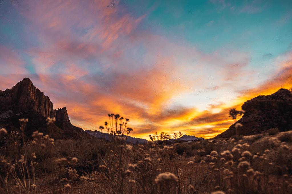
Zion National Park (Springdale, Utah)
Upon entering Zion National Park, we drove right past the entrance station, as it was closed for the evening. We proceeded into the park and made it about fifteen minutes in when we saw flashing lights behind us. We were getting pulled over by a National Park Ranger. He approached the window and informed us that “The Dutchmen” would not fit in the tunnel we’d be soon approaching. Instead of making us turn around and drive an extra hour and a half to Virgin, Utah where our RV park was located, he was really kind and explained the plan to get us through the tunnel. We would follow him until he flashed his break lights, which was our cue to pull off to the side of the road. Then we’d have to wait exactly 5 minutes for him to get set up and block traffic from the other direction before we could come through the tunnel. At the 5 minute mark there were still several cars coming in our direction. We waited 1 more minute, crossed our fingers and then headed in. The tunnel was long. SO LONG. It felt like we were in there for hours. It was dark and tight, a claustrophobic nightmare. We drove down the center line. I was literally sitting on the edge of my seat, clutching onto the “Oh shit” bar in front of me. I could even tell Michael was kind of nervous, which is a rarity. After what felt like two hours, we made it out and flashed our lights at the oh-so kind Park Ranger who was waiting in front of us. So, if you have a camper or any kind of trailer, DO NOT ENTER the park from Zion’s East Entrance. We learned later that people with oversized vehicles can arrange an escort during regular business hours for $15 dollars to stop traffic for you on the other side of the tunnel.
Zion is known for much of it’s beauty and the fact that it was named Utah’s first and most popular park. It sees about 1 million visitors per year. Two of its most famous hikes include Angels Landing and the Narrows. Our friends Max and Ashley who we met on our way to Cassidy Arch in Capitol Reef, NP informed us that prior to hiking the Narrows, we should visit Zion Outfitters to rent dry suits.
Must-Do’s in Zion National Park
- Angel’s Landing- This hike is no joke. When searching “Zion National Park” on Google, Angel’s Landing and The Narrows always come up as the most popular, not just for Zion but for all of Utah. They are also Zion’s only two “Strenuous” hikes. According to an article titled “The 10 Most Dangerous Hikes in the World” published by Eureka in 2016, Angel’s Landing is ranked at #1. The article says, “This wickedly narrow trail is not for the timid. Though the 5-mile path is well maintained and even paved in places, the last half-mile ascends over 1,400 feet along a slippery spine of sandstone that drops off hundreds of feet on either side. Several people have fallen to their deaths trying to reach the formation’s, 5,700-foot peak in the past decade alone. One seasonal hiker said, “It scared the hell out of me.”
Tips for Conquering Angel’s Landing:
- Wake up early and begin as soon as the sun comes up (If you don’t, it’s a guarantee the climb will be uncomfortably crowded- yes, it’s that popular)
- Wear gloves, the chains are ice cold during the Winter months
- Wear a Camelbak, you won’t have room to stop and drink so this is the best option
- Bring a snack or lunch to enjoy at the top
- Mentally prepare yourself ahead of time. Make sure you know what you’re getting into. Kids are not allowed, nor are adults who are afraid of heights
- Give yourself time to complete it, so you don’t feel rushed. The terrain is very rigid and dangerous.
- Wear proper hiking boots. Some hikes you can get away with running sneakers, but this is not the one
- Bring a camera- the view is incredible and must be documented
Tips for Conquering The Narrows:
- The night prior, rent dry suits from Zion Outfitters (Located right in town near the Visitor Center and Zion Brewery) In the Summer you should only need neoprene booties/boots.
- Arrive early again to beat the crowds. Anytime before 10am is fine as long as it’s not a Weekend.
- Make sure you have a walking stick (This comes with your rental at Zion Outfitters) It’s important when forging through the river
- Bring lunch!! This hike can last up to eight hours if you do it entirely.
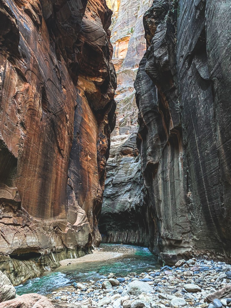
The Narrows– Our Experience
On day 1 in Zion we decided we wanted to go all-in and hike The Narrows. I rented a full dry suit with neoprene booties for $60, and Mike chose to wear his fishing waders. We spent about four hours hiking through the Virgin River, wading through the ice cold water in our boots, while doing our best to also soak in the incredible sandstone walls standing on either side of us. The water was anywhere from knee deep to above our hips at certain points, which made it fun and kind of unpredictable. Luckily for Mike and I, we’re both tall so we didn’t get as submerged as others. As we turned one of the corners, we ran into our friends Calvin and Anna from Florida, who are on their honeymoon. We met them in Canyonlands NP and realized we were both doing the Mighty Five. Calvin and Mike made small talk about their cameras and the four of us quickly became friends. That evening we met at the Zion Brewpub for dinner and drinks. For a Brewery, we were impressed by their menu, it wasn’t just chicken wings and burgers for once. I also had a super tasty Pomegranate sour beer which hit the spot, if you like sours. The four of us talked non-stop for the next three hours until we realized the restaurant had completely cleared out and was about to close. We promised to grab dinner again next time we’re in Ft. Myers and went our separate ways.
Our plan the very next morning was to wake up and take on Angel’s Landing first thing. I woke up to the sound of the wind roaring through our stove vent. The day would come with a wind advisory, which would have probably made the hike up Angel’s Landing even more terrifying. I also should note that I was slightly hungover from those two beers the night before, but that’s besides the point. We decided to lay low and spend the day visiting little shops in Springdale. We had a delicious lunch at MeMe’s Diner then biked in the park and rode the Pa’Ru trail up to the entrance of the Grotto. It was awesome to bike through the park around dusk and see the mule deer run out in front of us. Mike spent a solid hour taking pictures of the deer that were eating along the Virgin River before we headed back to the Dutchmen for the night.
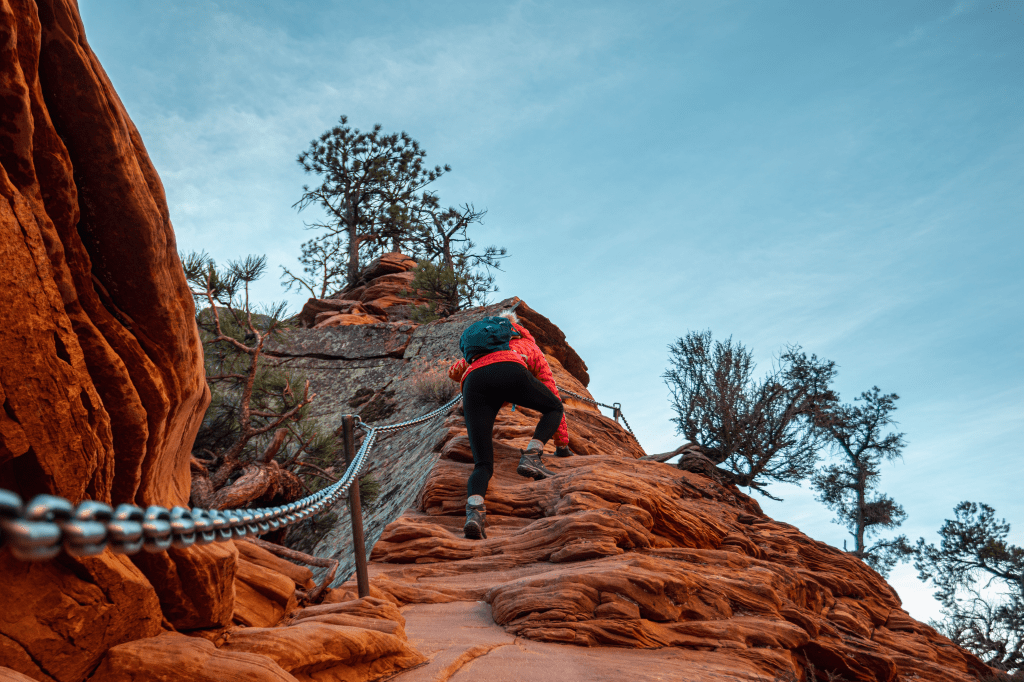
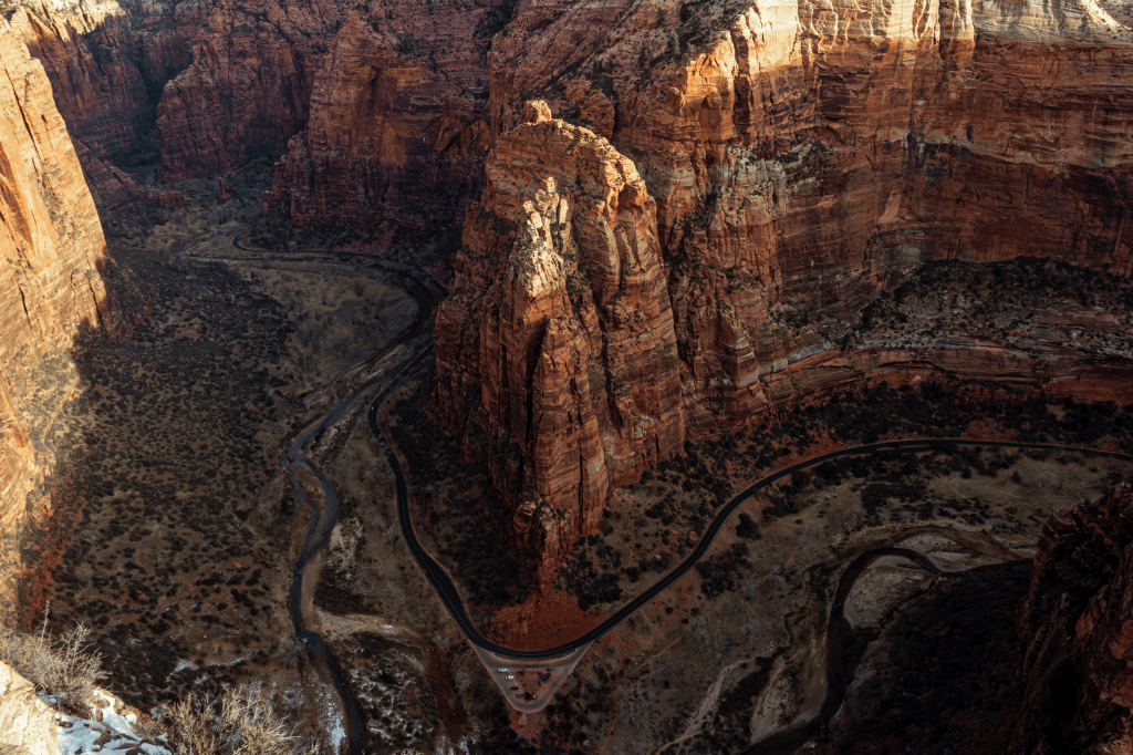
Angel’s Landing– Our Experience
On November 6th 2020, Mike and I were about to reach the summit of Sunset Peak in Heber Valley, Utah when I started having a panic attack to the point where I couldn’t walk, let alone stand. Flash forward to January 10th, the day we’d attempt Angel’s Landing in Zion National Park. One of the most dangerous hikes in the US. “Angels Landing received its name in 1916 when a group passing through the canyon commented that only an angel could land on top of it. The trail to the summit was constructed in 1926 and includes a remarkable series of 21 short switchbacks called ”Walters Wiggles”.
We woke up to the sound of his iPhone alarm at 6am. I popped out of bed immediately and took Berk outside for a walk in the dark. For me it felt like game day. If you were ever an athlete in High School or College you can probably understand this feeling. You wake up so focused solely on the fact that it’s game day. You eat quickly and feel anxious for what lies ahead. You have butterflies in your stomach and feel a healthy sense of jitters, looking at the clock counting down the hours until it’s time. In this case, Angel’s Landing was the team to beat and man, we were prepared. We had hiked, mountain biked and/or ran almost everyday for the past three months, so there was no internal question of our athletic abilities, but rather the strength of our minds.
The other team was prepared, we had read articles and heard endless whispers around Zion about the climb. How it had chewed people up and spit them out thousands of times before. What made us any different? After all, my childhood fear of heights would certainly be present, whether I liked it or not. I had to face this fear at some point and it felt like today was the day. Over the last decade alone, a dozen people fell to their deaths attempting to beat this mountain and win the so-called “game.”
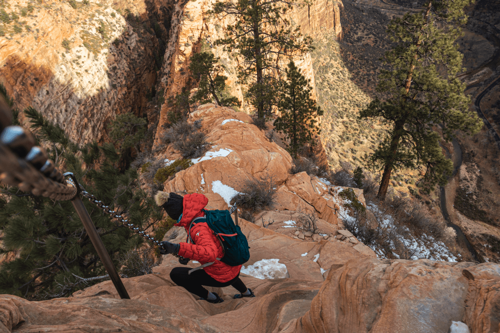
Angels Landing, a 5,350 cliff that doesn’t allow children, people fearful of heights (me) and greets you with a sign that lists the number of deaths that have occured since 2010, is not for the faint of heart. We began around 8am and headed right for Walter’s Wiggles. They gave me enough time to burn my thighs just enough to distract me from the chains I would soon be grasping for my dear life. When I reached them, I held on tight in order to stay semi-vertical, with the cliff edges dropping over 1500 feet on either side. I let go of one of the chains only to find myself at the steps of faith (no chains). I immediately turned to my husband and said, “I don’t think I can go any further” and started to panic. A random girl who was behind me wearing a burnt orange coat and grey winter cap told me it was okay and that she would walk with me. Then she grabbed my hand, which obviously made me more emotional, because who does that? We carried on up in a group making small talk with her and her boyfriend who were from Salt Lake City. We climbed for another fifteen minutes or so (1.1 miles total holding on the chains) some rocks were slick with ice, others slippery because of the loose sand they were covered in. The wind was strong, which made me want to grip the chains even tighter. I didn’t look down. I didn’t even think about looking down the whole time. Meanwhile, behind me my husband was gawking at the view below and telling me all about it. I told him I didn’t care and just wanted to make it to the top in one piece. I talked to myself, like a crazy person, saying things like “You got this” and “It’s okay, don’t worry you’ll be okay.” I focused on my breathing a lot. If it wasn’t for the last year of yoga I’m not sure I could’ve done it without a major breakdown. I took deep, harsh breaths, sucking in every bit of wind that blew my way.
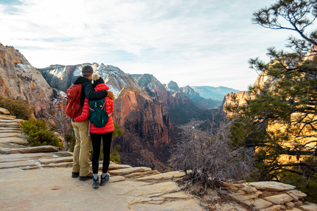
When we reached the landing, I tried to hide the tears streaming down my cheeks. There were 8 or 10 people there celebrating their victory and some were standing one step too close to the edge for comfort. There was a sense of comradery with every other person on the mountain unlike any other hike we’ve completed. Mike took pictures while I made friends with Max, a frat boy from New York who currently attends Penn State and came out to Zion alone. Max and I also chatted with Daisy and Chris, a fearless couple who were waiting at the top for almost an hour, waiting for the sun to come out. I could still feel my adrenaline pumping, later I’d find out from my Apple Watch that my heart rate averaged 117 BPM and peaked at 160 BPM. On average my BPM is in the 90s when I hike. I was so proud of myself, it was a feeling I couldn’t describe. I was relieved but still scared to death of what could have been. Luckily for me I didn’t research the death statistics until after we were back on solid ground, but that did not lessen their weight. For those of you who want to truly understand this hike, go online and search Angels Landing on YouTube. Or read the article from Eureka titled “10 Most Dangerous Hikes in the World”, where Angels Landing came in at #1.
So if you ever get the chance, don’t skip out on the opportunity to visit one, if not all of Utah’s “Mighty 5” National parks.
